Projects
IDIQ Contract for Surveying and Mapping – Contract No. W912PL-06-D-0013
This contract was awarded in September 2006. A total of 48 task orders were issued, totaling just over $5,000,000. Of these projects, twenty five were aerial mapping or a combination of aerial and ground survey mapping, nine were boundary retracement and/or right of way acquisition projects together with mapping, two were GIS Parcel base georectification and verification, one was utility research and retracement, and two were conventional ground based topographic mapping. We received Very Good ratings on all but two of the tasks, which received Satisfactory ratings. The details of a few of these projects are as follows:
Lower Santa Ana River, Orange County, California: This project included 19 aerial control panels and aerial mapping of over 1,225 acres of residential, golf course, and river bed terrain. The project required access to restricted railroad and CalTrans rights of way as well as access to an adjacent State Park. This project was completed on time and within budget.
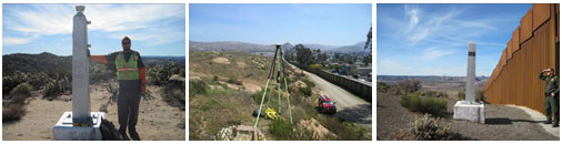
Boulevard CBP Site, San Diego County, California: This project included performing a boundary and ALTA survey of a site to be purchased and developed for use as a Customs and Border Protection Facility. It involved retracing sectional and CalTrans right of way lines, the compilation of an ALTA map, monumentation, and recordation of a Record of Survey. This project was completed on time and within budget.
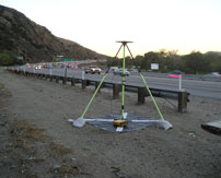
Matilija Dam Removal Project, Ojai, California: This involved retracing and recovering sectional lines and monumentation not seen since the original survey of 1878. These are the type of projects we surveyors live for; there is no better satisfaction than finding a corner that nobody else has been able to find in the last 130 years. In all, we found nine monuments, four perpetuated original monuments for which a record had not been filed, two 80 year old 1/16th corners, one 80 year old reference monument, one original bearing tree which referenced an original line monument, and one original 1878 rock mound. This data was then used to adjust the Ventura County GIS parcel base to a more reality based location. In addition, a Record of Survey was recorded in order to perpetuate the results of this effort for future generations.
Contact: Mr. Alan Nichols, U.S. Army Corps of Engineers – (626) 401-4010
Aerial Mapping of 10 Cities within the Navajo Nation
Los Angeles District, US Army Corps of Engineers
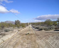
This project consisted of surveying and mapping services for flood plane studies throughout the Navajo Nation and focused on 10 of the largest population centers within the Nation. These sites were spread out across a vast area covering Arizona and New Mexico, and crossing three separate State Plane Zones. The sites included Ft. Defiance, Kayenta, Tuba City, Chinle, Leupp, Many Farms, and Ganado in Arizona, as well as Tohatchi, Shiprock, and Crownpoint in New Mexico. This project was Task 24 under contract W912PL-06-D-0013 and totaled $497,792 in professional services.
The 10 project areas covered 117 square miles, nearly 75,000 acres, required 86 individual permanent control aerial targets, and was flown at a photo scale of 1”=1200’ with Airborne GPS control. The resulting products were produced at a scale of 1”=160’ with a 4 foot contour interval. For each site, the established permanent survey control was compiled into a control map together with DA1959 data sheets for each station. Each site was delivered in Microstation together with an InRoads surface, ESRI Geodatabases, digital orthophotography, and photo indexes. All of the data was submitted to the Corps and in turn forwarded to the Nation for their future use.
Most importantly, the project required close cooperation with that Navajo people. Our crews required escorts at all times which required our schedule to be flexible to accommodate theirs. We found the Navajo people, and our escort in particular, to be extremely helpful and friendly. The success of this project hinged on these escorts as many of the people on the Reservation still speak Navajo, do not speak English, and are many times distrustful of outsiders.
The project was a high priority task for the Los Angeles District Colonel. It was fast tracked from the beginning. Estimating, negotiating, and contracting were completed within less than a month. The project was begun immediately upon notice to proceed and was completed within the 6 month period of service as requested. Johnson-Frank received an Very Good Performance Rating for this project.
Contact: Mr. Alan Nichols, U.S. Army Corps of Engineers – (626) 401-4010
Boundary and ROW Acquisition, PF225 Border Fence
Los Angeles District, US Army Corps of Engineers
This project consisted of boundary and cadastral surveying for right of way acquisitions along the U.S. / Mexico International Border. Specifically, the acquisitions involved existing roads currently being used by Customs and Border Protection (CBP), as well as roads and staging areas that were utilized in the construction of the new border fence. Many of these roads have been utilized by CBP for years, however, no legal right existed to allow such use. As such, numerous properties had to be surveyed, along with said roads and staging areas, in order to compile legal descriptions to facilitate acquisitions and/or condemnations.
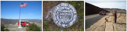
To date, this project has involved 4 separate task orders and three modifications to the fourth task order, a total of 29 separate owners and 31 individual parcels from west of Tecate in San Diego County to west of Calexico in Imperial County. The projects cover approximately 13 fractional townships along the border, requiring extensive cadastral retracement throughout the area.
This project consists of Tasks 17, 20, 27, 38, and modifications 1, 2, and 3 to Task 38, under contract W912PL-06-D-0013 and total $409,225 in professional services.
Contact: Mr. Alan Nichols, U.S. Army Corps of Engineers – (626) 401-4010
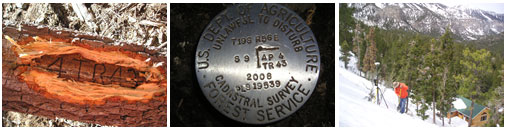
Lee and Kyle Canyon Boundary Surveys
Mt. Charleston, NV
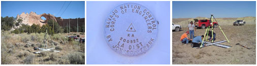
This project involved retracing and remarking the Forest Boundary lines surrounding private in holdings in Lee and Kyle Canyons. The project required the retracing and posting of 4 miles of Federal / Private Boundary lines. The survey required location and/or retracing the sectional controlling corners for three sections, as well as Tracts within the independent resurvey of T19S, R56E, MDM. Elevations throughout the project area ranged 7,500 to 8,500 feet. A total of approximately 7,500 total station, Static, and RTK observations comprise the final least squares network adjustments. Approximately 86 Forest Service dig-in monuments, set in concrete, were set marking the resurveyed boundaries. Three Records of Survey are being compiled, one of which, Lee Canyon, has already been filed and is included as one of the sample plats herein. The project was performed efficiently by first computing state plane coordinate search locations for all record monumentation using Star*Net Least Squares and all existing records weighted appropriately for the period in which the boundary control monuments were set. Then, using the best combination of RTK GPS and Total Stations, we physically located all necessary boundary control. Once found, and generally at the same visit, the existing monumentation was tied to control using Static GPS and/or Total Station network traverse. All final monuments were set by total station kick-overs from control established during the search phase of the project. All found and set corners were rigidly tied to the National Spatial Reference System and those resulting positions recorded on the filed Records of Survey to preserve the precise location of all corners and lines.
Contact: Mr. Bill Dempsey, U.S. Forest Service – (775) 352-1242
Wrightwood Forest Health Project
Wrightwood, CA
As part of the overall Forest Health Project, this project involved retracing and remarking the Forest Boundary lines surrounding the community of Wrightwood. In all, it required the retracing and maintaining of 5 miles of previously posted line, along with locating, monumenting, flagging and posting to Forest Standards of 10 miles of previously unsurveyed and unposted forest boundary line which followed sectional breakdown lines. Locating the previously unsurveyed lines required location and/or retracing the sectional controlling corners for eight complete sections and portions of several others, all in very steep and rugged mountainous terrain with 3000’± of elevation difference.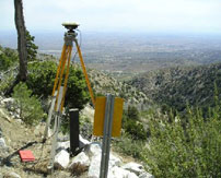 In addition to existing monumentation found, positioned and used for the forest corners, 15 new USFS standard post monuments were set to define previously unmonumented corners. Records of Survey of twelve sheets each, were filed in both Los Angeles and San Bernardino Counties, addressing the idiosyncrasies of both counties – not a small task on it’s own. The project was performed efficiently by first computing state plane coordinate search locations for all record monumentation using Star*Net Least Squares and all existing records weighted appropriately for the period in which the boundary control monuments were set. Then, using the best combination of Static GPS, RTK GPS, Total Stations, compass, chain, and will power, we physically located all necessary boundary control. Once found, and generally at the same visit, the existing monumentation was tied to control using Static GPS with Total Station offsets for those locations where GPS would not function. All final monuments were set by total station kick-overs from close Static GPS points positioned in the search phase of the project. All found and set corners were rigidly tied to the National Spatial Reference System through GPS static connections to two bracketing Continuous Operating Reference Stations (CORS), and those resulting positions recorded on the filed Records of Survey to preserve the precise location of all corners and lines.
Contact: Mr. Howard Whitman, U.S. Forest Service – (707) 562-8963
Aerial / Orthophotography Control, Airborne GPS Control, and Geodetic Control
Johnson-Frank has provided aerial control services for thousands of projects over our 36-year history. Many of these projects have been citywide mapping and orthophotography projects including the cities of Arcadia, Burbank, Fontana, Fountain Valley, Huntington Beach, Loma Linda, Newport Beach, Ontario, Rancho Cucamonga, Santa Monica, Seal Beach, and Universal Studios, among numerous others. Of the projects listed above, the Cities of Newport Beach, Huntington Beach, Corona, and Fountain Valley included the use of Airborne GPS (AGPS) control. This methodology positions the aircraft at the instant of photo exposure and reduces the number of ground control necessary, thereby reducing the overall cost of the project. Another recent project also utilized this technology, it included 2,573 AGPS controlled photo exposures and 242 ground control stations.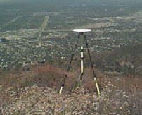 This project was performed for the San Diego County Water Authority, the Cities of Coronado, Chula Vista, Oceanside, and Encinitas and covered most of San Diego County including every San Diego County Water Authority corridor throughout the County. In addition to being utilized as photogrammetric control, this countywide GPS network was performed to First Order standards and has been filed as a GPS Control Record of Survey (ROS 17488). Said control is available to and currently in use by public and private surveyor’s throughout the county. A similar product was produced for the City of Burbank, while observing the citywide orthophotography control; we were tasked with simultaneously recovering, rebuilding, and updating their citywide geodetic control network. The City now has a citywide geodetic control map which is available to public and private surveyors.
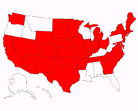
As Johnson-Frank developed with a “Public Service” focus, we also developed with an emphasis on geodetic horizontal and vertical control, high quality, reliable aerial control, high precision deformation monitoring, and quality, reliable ground based and aerial mapping products. As such, our firm has been providing these services, including horizontal and vertical control, since long before GPS was invented. Our firm provided the City of Irvine with its’ first city wide horizontal control network in 1981. Subsequently, with the advent of GPS, the transition was an obvious step in our firms’ growth. Being one of the early players in the GPS industry (first units purchased in 1988), our firm has amassed extensive knowledge and experienced utilizing the technology for any and all types of projects throughout the United States. In all, our firm has completed GPS geodetic and aerial control projects in 35 of the 48 contiguous states. Over our 23 years of providing GPS services, our firm has completed thousands of projects and performed all related services.
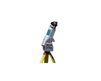
Laser Scanning Survey Services
Johnson-Frank & Associates, Inc. began providing Laser Scanning services in January 2005. Since that time, we have successfully employed this technology on numerous projects throughout Southern California, Arizona, and New Mexico. The most notable of these projects were for Vulcan Materials, the City of Mission Viejo, the City of Santa Ana, and the Exposition Metro Line Construction Authority.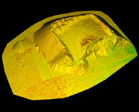
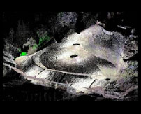
Vulcan Materials
Johnson-Frank & Associates, Inc. employed Laser Scanning Technology to more economically and accurately survey and calculate volumes for stockpiles at 6 separate gravel quarries located in Southern California, Arizona, and New Mexico. This project included 177 individual scans and the creation of digital terrain model’s and volume calculations for 164 individual stockpiles.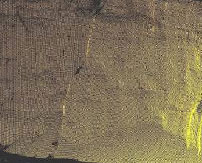
Johnson-Frank also employed Laser Scanning Technology to assist Vulcan Materials with gravel quarry high wall analysis on three quarries located in Southern California. This involved scanning near vertical cliffs that could not have been surveyed conventionally and generating cross sections at specified locations along the walls of these quarries.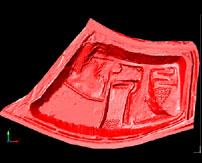
Johnson-Frank employs Laser Scanning Technology on various on-going earth moving projects for Vulcan Materials. These range from scanning and calculating volumes for single stock piles or borrow areas, to scanning entire quarries and calculating volumes for pay quantities for various individual sections of the quarry. These surveys provide high accuracy results while not interrupting the on-going work, and while keeping all survey personnel out of harm’s way, away from the heavy machinery traversing the pit floor.
Contacts: Mr. Chris Di Maggio – (323) 474-3316
Mr. Larry Lao – (323) 474-3392
Mr. Jock Scott – (626) 351-4269
City of Mission Viejo
Johnson-Frank employed Laser Scanning Technology in Mission Viejo in connection with slope failure monitoring and slope reconstruction. This project required us to capture the re-constructed slope in a very short period of time so that plastic covering could be placed over the slope prior to oncoming rains. Having a short time frame and an unknown list of features to capture made Laser Scanning an ideal choice for this project. Having a virtual world allowed us to extract features that were originally not thought necessary by engineering and geotechnical professionals involved with the project.
Contact: Mr. Rich Schlesinger – (949) 470-3079
City of Santa Ana
Johnson-Frank was contracted by the City of Santa Ana to provide topographic mapping of arterial streets throughout the City. The project consisted of 8 sections of arterial roads, a total of 6 miles in all. For safety and time constraint reasons, Johnson-Frank decided to employ a combination of conventional survey and Laser Scanning Technology.
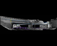 Conventional survey was used to recover and control the street centerlines, survey utility features, and survey features outside of traffic. Meanwhile, Laser Scanning Technology was used to survey the pavement areas as well as provide a quality check on the completeness of the conventional survey. Most importantly, this allowed our field staff to minimize their time in traffic, and therefore greatly reduce the possibility of injuries.
Contact: Mr. Jason Gabriel – (714) 647-5664
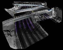
Exposition Metro Line Construction Authority
As a member of the design-build team for the Mid-City/Exposition Light Rail Transit Project, Johnson-Frank employed Laser Scanning Technology to survey the freeway surface and the undersides of the Flower and Adams bridges over the 110 freeway. Laser Scanning Technology allowed us to obtain a high degree of accuracy on the structures in question and it allowed us to do so without any freeway lane closures or traffic obstructions of any kind. In addition, it allowed us to keep our survey personnel out of harm’s way, away from the high speed traffic on the freeway at all times.
Contact: Mr. Calvin Yoshitake – (562) 863-7762